15-2.3-2 Uses
15-2.3-3 Lot And Site Requirements
15-2.3-4 Existing Historic Buildings And/or Structures
15-2.3-5 Building Height
15-2.3-6 Development On Steep Slopes
15-2.3-7 Conditional Use Permit Review
15-2.3-8 Special Requirements For Master Planned Developments And Conditional Use Permits In Sub-Zone A
15-2.3-9 Special Requirements For Sub-Zone B
15-2.3-10 Mechanical Service
15-2.3-11 Criteria For Bed And Breakfast Inns
15-2.3-12 Parking Regulations
15-2.3-13 Architectural Review
15-2.3-14 Vegetation Protection
15-2.3-15 Signs
15-2.3-16 Related Provisions
The purpose of the HR-2 District is to:
- allow for adaptive reuse of Historic Buildings and/or Structures by allowing commercial and office Uses in Historic Buildings and/or Structures in the following Areas:
- Upper Main Street;
- Upper Swede Alley; and
- Grant Avenue;
- Upper Main Street;
- encourage and provide incentives for the preservation and renovation of Historic Buildings and/or Structures;
- establish a transition in Use and scale between the HCB, HR-1, and HR-2 Districts, by allowing Master Planned Developments in the HR-2, Subzone A;
- encourage the preservation of Historic Buildings and/or Structures and construction of historically Compatible additions and new construction that contributes to the unique character of the Historic District;
- define Development parameters that are consistent with the General Plan policies for the Historic core that result in Development that is Compatible with Historic Buildings and/or Structures and the Historic character of surrounding residential neighborhoods and consistent with the Design Guidelines for Historic Districts and Historic Sites and the HR-1 regulations for Lot size, coverage, and Building Height;
- provide opportunities for small scale, pedestrian oriented, incubator retail space in Historic Buildings and/or Structures on Upper Main Street, Swede Alley, and Grant Avenue;
- ensure improved livability of residential areas around the historic commercial core;
- encourage and promote Development that supports and completes upper Park Avenue as a pedestrian friendly residential street in Use, scale, character and design that is Compatible with the Historic character of the surrounding residential neighborhood;
- encourage residential development that provides a range of housing opportunities consistent with the community’s housing, transportation, and historic preservation objectives;
- minimize visual impacts of the automobile and parking by encouraging alternative parking solutions; and
- minimize impacts of Commercial Uses on surrounding residential neighborhood.
Uses in the HR-2 District are limited to the following:
- ALLOWED USES.
- Single Family Dwelling
- Lockout Unit1
- Nightly Rental2
- Home Occupation
- Child Care, In-Home Babysitting3
- Child Care, Family Group3
- Accessory Building and Use
- Conservation Activity
- Agriculture
- Residential Parking Area or Structure with four (4) or fewer spaces
- Internal Accessory Dwelling Unit12
- Accessory Apartment4
- Single Family Dwelling
- CONDITIONAL USES.
- Duplex Dwelling
- Secondary Living Quarters
- Group Care Facility
- Child Care Center
- Public or Quasi-Public institution, church or school
- Essential municipal and public utility Use, facility, service, and Structure
- Telecommunication Antenna5
- Satellite Dish Antenna greater than thirty-nine inches (39") in diameter6
- Bed and Breakfast Inn7
- Boarding House, Hostel7
- Hotel, Minor, fewer than sixteen (16) rooms7
- Office, General8
- Office, Moderate Intensive8
- Office and Clinic, Medical8
- Retail and Service Commercial, Minor8
- Retail and Service Commercial, personal improvement8
- Cafe or Deli8
- Outdoor Events
- Residential Parking Area or Structure with five (5) or more spaces, associated with a residential Building on the same Lot
- Temporary Improvement
- Passenger Tramway Station and Ski Base Facility10
- Ski tow rope, ski lift, ski run, and ski bridge10
- Recreation Facility, Private13
- Fences greater than six feet (6') in height from Final Grade11
- Limited Commercial expansion necessary for compliance with Building/ Fire Code egress and Accessibility requirements and support Uses associated with HCB Commercial Use
- Bar8
- Temporary Structures, excluding yurts.14
- Duplex Dwelling
- PROHIBITED USES. Any Use not listed above as an Allowed or Conditional Use is a prohibited Use.
1Nightly Rental of Lockout Units requires a Conditional Use Permit.
2Nightly Rental does not include the use of dwellings for Commercial Uses.
3See Section 15-4-9 Child Care And Child Care Facilities. Family Group Child Care and Child Care Center Uses require an Administrative Conditional Use permit.
4Requires an Administrative Permit. See Section 15-4-7, Accessory Apartments.
5See Section 15-4-14, Telecommunication Facilities.
6See Section 15-4-13, Placement Of Satellite Receiving Antennas.
7In Historic Buildings and/or Structures only.
8In Historic Buildings and/or Structures and within Sub-Zones A and B subject to compliance with all criteria and requirements of Section 15-2.3-8 for Sub-Zone A and Section 15-2.3-9 for Sub-Zone B.
9Subject to an Administrative Conditional Use Permit, and permitted in Sub-Zone B only, subject to requirements in Section 15-2.3-9.
10See Section 15-4-18, Passenger Tramways And Ski-Base Facilities.
11See Section 15-4-2, Fences And Retaining Walls.
12See Section 15-4-7.1, Internal Accessory Dwelling Units. Single-Family Dwellings designated Significant or Landmark Historic Sites on the Park City Historic Sites Inventory are subject to an Administrative Conditional Use Permit.
13See Section 15-4-22, Outdoor Pickleball Courts in Residential Areas.
14Requires an Administrative Permit. See Section 15-13-10, Standards for Temporary Structures in Historic Districts.
Adopted by Ord. 00-51 on 9/21/2000
Amended by Ord. 04-08 on 3/4/2004
Amended by Ord. 06-56 on 7/27/2006
Amended by Ord. 09-10 on 3/5/2009
Amended by Ord. 10-14 on 4/15/2010
Amended by Ord. 12-37 on 12/20/2012
Amended by Ord. 15-35 on 10/12/2015
Amended by Ord. 2020-36 on 7/30/2020
Amended by Ord. 2020-42 on 9/17/2020
Amended by Ord. 2021-38 on 9/23/2021
Amended by Ord. 2021-51 on 12/16/2021
Amended by Ord. 2022-08 on 4/28/2022
Amended by Ord. 2024-11 on 5/23/2024
Amended by Ord. 2025-11 on 6/5/2025
Except as may otherwise be provided in this Code, no Building Permit shall be issued for a Lot unless such Lot has Area, width, and depth as required, and Frontage on a private or Public Street shown on the Streets Master Plan, or on a private easement connecting the Lot to a Street shown on the Streets Master Plan.
All Development activity must comply with the following minimum Lot and Site requirements:
- LOT SIZE. The minimum Lot Area is 1,875 square feet for a Single Family Dwelling and the maximum Lot Area is 3,750 square feet. The minimum Lot Area is [and] 3,750 square feet for a Duplex Dwelling and the maximum Lot Area is 7,500 square feet. For properties platted as lots within the historic Park City Survey and originally platted as 25 feet wide by 75 feet deep with a lot size of 1,875 square feet, the Planning Director may make a determination that the minimum Lot Size may be reduced up to 20 square feet if subsequent surveys find that the final lot dimensions are less than 25 feet by 75 feet. The Footprint shall be reduced in accordance with the Lot Size and no variation to setbacks will be allowed. The Minimum Lot Area for all other Uses shall be determined by the Planning Commission during the Conditional Use or Master Planned Development review process.
- LOT WIDTH. The minimum width of a Lot is twenty five feet (25'), measured fifteen feet (15') back from the Front Lot Line. In the case of unusual Lot configurations, Lot width measurements shall be determined by the Planning Director.
- BUILDING ENVELOPE (HR-2 DISTRICT). The Building Pad, Building Footprint and height restrictions define the maximum Building Envelope within which all Development must occur with exceptions as allowed in Section 15-2.3-4.
- BUILDING PAD (HR-2 DISTRICT). The Building Pad is the Lot Area minus required Front, Rear, and Side Setback Areas.
- The Building Footprint must be within the Building Pad. The remainder of the Building Pad must be open and free of any Structure except:
- Porches or decks, with or without roofs;
- At Grade patios;
- Upper level decks, with or without roofs;
- Bay Windows;
- Chimneys;
- Sidewalks, pathways, and steps;
- Screened hot tubs; and
- Landscaping.
- Porches or decks, with or without roofs;
- Exceptions to the Building Pad Area, excluding Bay Windows, are not included in the Building Footprint calculations, and are subject to Planning Director approval based on a determination that the proposed exceptions result in a design that:
- provides increased architectural interest consistent with the Design Guidelines for Historic Districts and Historic Sites; and
- maintains the intent of this section to provide horizontal and vertical Building articulation.
- provides increased architectural interest consistent with the Design Guidelines for Historic Districts and Historic Sites; and
- The Building Footprint must be within the Building Pad. The remainder of the Building Pad must be open and free of any Structure except:
- BUILDING FOOTPRINT (HR-2 DISTRICT).
- The maximum Building Footprint for any Structure located on a Lot, or combination of Lots, not exceeding 18,750 square feet in Lot Area, shall be calculated according to the following formula for Building Footprint. The maximum Building Footprint for any Structure located on a Lot or combination of Lots, exceeding 18,750 square feet in Lot Area, shall be 4,500 square feet; with an exemption allowance of 400 square feet per Dwelling Unit for garage floor area. A Conditional Use permit is required for all Structures with a proposed footprint greater than 3,500 square feet.
Accessory Buildings listed on the Park City Historic Sites Inventory that are not expanded, enlarged or incorporated into the Main Building, shall not count in the total Building Footprint of the Lot. - See Section 15-6-5 for maximum allowed Building footprint for Master Planned Developments within the HR-2 District.
MAXIMUM FP = (A/2) x 0.9A/1875
Where FP = maximum Building Footprint and A= Lot Area.
Example: 3,750 sq. ft. lot: (3,750/2) x 0.9(3750/1875) = 1,875 x 0.81 = 1,519 sq. ft. TABLE 15-2.3.a
Lot Depth Min. Front/Rear Setback Total of Setbacks Up to 75 ft., inclusive 10 ft. 20 ft. From 75 ft. to 100 ft. 12 ft. 25 ft. Over 100 ft. 15 ft. 30 ft.
- The maximum Building Footprint for any Structure located on a Lot, or combination of Lots, not exceeding 18,750 square feet in Lot Area, shall be calculated according to the following formula for Building Footprint. The maximum Building Footprint for any Structure located on a Lot or combination of Lots, exceeding 18,750 square feet in Lot Area, shall be 4,500 square feet; with an exemption allowance of 400 square feet per Dwelling Unit for garage floor area. A Conditional Use permit is required for all Structures with a proposed footprint greater than 3,500 square feet.
- FRONT AND REAR SETBACKS. Front and Rear Setbacks are as follows:
TABLE 15-2.3aLot Depth Min. Front/Rear Setback Total of Setbacks Up to 75 ft., inclusive 10 ft. each 20 ft. From 75 ft. to 100 ft. 12 ft./13 ft. (or vice versa) 25 ft. Over 100 ft. 15 ft. each 30 ft. - FRONT SETBACK EXCEPTIONS. The Front Setback must be open and free of any Structure except:
- Fences, walls, and retaining walls not more than four feet (4') in height or as permitted in Section 15-4-2, Fences and Retaining Walls. On Corner Lots, Fences more than three feet (3') in height are prohibited within twenty-five feet (25') of the intersection, at the back of curb.
- Uncovered steps leading to the Main Building; provided, the steps are not more than four feet (4') in height from Final Grade, not including any required handrail, and do not cause any danger or hazard to traffic by obstructing the view of the Street or intersection.

- Decks, porches, or Bay Windows not more than ten feet (10') wide and projecting not more than three feet (3') into the Front Setback.
- Roof overhangs, eaves or cornices projecting not more than three feet (3') into the Front Setback.
- Sidewalks and pathways.
- Driveways leading to a Garage or approved Parking Area. No portion of a Front Yard except for driveways, allowed Parking Areas and sidewalks, may be Hard-Surfaced or graveled.
- Single car detached Garages approved as part of a Master Planned Development in Subzone A.
- Fences, walls, and retaining walls not more than four feet (4') in height or as permitted in Section 15-4-2, Fences and Retaining Walls. On Corner Lots, Fences more than three feet (3') in height are prohibited within twenty-five feet (25') of the intersection, at the back of curb.
- REAR SETBACK EXCEPTIONS. The Rear Setback must be open and free of any Structure except:
- Bay Windows not more than ten feet (10') wide, and projecting not more than two feet (2') into the Rear Setback.
- Chimneys not more than five feet (5') wide and projecting not more than two feet (2') into the Rear Setback.
- Window wells not exceeding the minimum International Residential Code (IRC) or International Building Code (IBC) requirements for egress may extend not more than four feet (4') into the Rear Setback. Should egress requirements be met within the building pad, no rear Setback exception is permitted.
- Roof overhangs or eaves projecting not more than two feet (2') into the Rear Setback.
- Window sills, belt courses, cornices, trim, exterior siding, or other ornamental features projecting not more than six inches (6") beyond the main Structure to which they are attached.
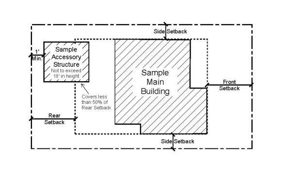
- Detached Accessory Buildings not more than eighteen feet (18') in height, and including any free-standing Solar Energy Systems, located a minimum of five feet (5') behind the front facade of the Main Building, and maintaining a minimum Rear Setback of one foot (1'). Such Structure must not cover over fifty percent (50%) of the Rear Setback. See the following illustration:
- A Hard-Surfaced Parking Area subject to the same location requirements as a detached Accessory Building.
- Mechanical equipment (which must be screened), hot tubs, or similar Structures located at least three feet (3') from the Rear Lot Line.
- Fences, walls, and retaining walls as permitted in Section 15-4-2 Fences and Retaining Walls.
- Patios, decks, steps, pathways, or similar Structures not more than thirty inches (30") above Final Grade, not including any required handrail, and located at least one foot (1') from the Rear Lot Line.
- Pathways or steps connecting to a City staircase or pathway.
- One (1) Shared Driveway leading to a garage or approved Parking Area. See Section 15-2.3-12 Parking Regulations for additional requirements.
- Bay Windows not more than ten feet (10') wide, and projecting not more than two feet (2') into the Rear Setback.
- SIDE SETBACKS. The Side Setbacks are as follows:
TABLE 15-2.3bLot Width (ft.) up to: Minimum Side Setback Total of Setbacks 25.0 3 ft. each 6 ft. 37.5 3 ft. each 6 ft. 50.0 5 ft. each 10 ft. 62.5 5 ft. 14 ft. 75.0 5 ft. 18 ft. 87.5 10 ft. 24 ft. 100.0 10 ft. 24 ft. Greater than 100.0 10 ft. 30 ft. - On Corner Lots, the minimum Side Setback that faces a side Street or platted Right-of-Way is five feet (5'). A three foot (3') Side Setback along the platted Right-of-Way may be approved by the City Engineer when the Lot Width is less than 37.5 feet; no Side Setback exceptions shall be utilized and the sight triangle shall be maintained when the Setback is three feet (3') along the Right-of-Way.
- A Side Setback between connected Structures is not required where Structures are designed with a common wall on a Property Line, each Structure is located on an individual Lot, the Lots are burdened with a party wall agreement in a form approved by the City Attorney and Chief Building Official, all applicable Building and Fire Code requirements are met, and the Use is an Allowed or Conditional Use in the Zoning District.
- Exterior Side Setbacks shall be based on the required minimum Side Setback for each Lot; however the Planning Commission may consider increasing exterior Side Setbacks during Conditional Use Permit review to mitigate potential impacts on adjacent Property. Side Setback exceptions continue to apply.
- Building Footprint shall be based on the total lot Area of the underlying Lots. The Planning Commission may consider decreasing Building Footprint during Conditional Use Permit review to mitigate potential impacts on adjacent Property.
- Exterior Side Setbacks shall be based on the required minimum Side Setback for each Lot; however the Planning Commission may consider increasing exterior Side Setbacks during Conditional Use Permit review to mitigate potential impacts on adjacent Property. Side Setback exceptions continue to apply.
- On Corner Lots, the minimum Side Setback that faces a side Street or platted Right-of-Way is five feet (5'). A three foot (3') Side Setback along the platted Right-of-Way may be approved by the City Engineer when the Lot Width is less than 37.5 feet; no Side Setback exceptions shall be utilized and the sight triangle shall be maintained when the Setback is three feet (3') along the Right-of-Way.
- SIDE SETBACK EXCEPTIONS. The Side Setback must be open and free of any Structure except:
- Bay Windows not more than ten feet (10') wide, and projecting not more than two feet (2') into the Side Setback. Only permitted on Lots with a minimum required Side Setback of five feet (5') or greater.
- Chimneys not more than five feet (5') wide and projecting not more than two feet (2') into the Side Setback. Only permitted on Lots with a minimum required Side Setback of five feet (5') or greater.
- Window wells not exceeding the minimum International Residential Code (IRC) or International Building Code (IBC) requirements for egress may extend not more than four feet (4') into the Side Setback. Only permitted on Lots with a minimum required Side Setback of five feet (5') or greater. Should egress requirements be met within the building pad, no Rear Setback exception is permitted.
- Roof overhangs or eaves projecting not more than two feet (2') into the Side Setback on Lots with a minimum required Side Setback of five feet (5') or greater. A one foot (1’) roof or eave overhang is permitted on Lots with a Side Setback of less than five feet (5’).
- Window sills, belt courses, trim, cornices, exterior siding, or other ornamental features projecting not more than six inches (6") beyond the main Structure to which they are attached.
- Patios, decks, pathways, steps, or similar Structures not more than thirty inches (30") in height from Final Grade, not including any required handrail.
- Fences, walls, and retaining walls as permitted in Section 15-4-2 Fences and Retaining Walls.
- One (1) private or Shared Driveway leading to a garage or approved Parking Area. See Section 15-2.3-12 Parking Regulations for additional requirements.
- Pathway or steps connecting to a City staircase or pathway.
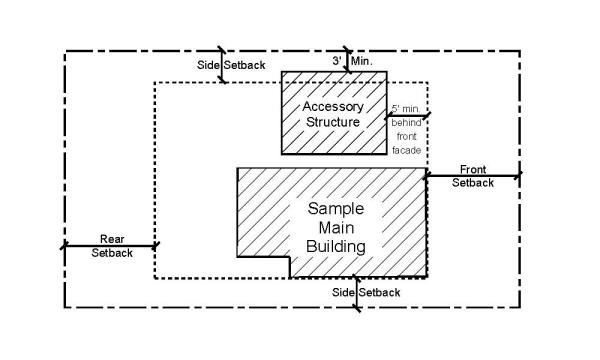
- Detached Accessory Buildings, not more than eighteen feet (18') in height, including any free-standing Solar Energy Systems, located a minimum of five feet (5') behind the front facade of the Main Building, maintaining a minimum Side Setback of three feet (3'). See the following illustration:
- Mechanical equipment (which must be screened), hot tubs, or similar Structures located at least three feet (3') from the Side Lot Line.
- Bay Windows not more than ten feet (10') wide, and projecting not more than two feet (2') into the Side Setback. Only permitted on Lots with a minimum required Side Setback of five feet (5') or greater.
- SNOW RELEASE. Site plans and Building designs must resolve snow release issues to the satisfaction of the Chief Building Official.
- CLEAR VIEW OF INTERSECTION. No visual obstruction in excess of two feet (2') in height above Road Grade shall be placed on any Corner Lot within the Site Distance Triangle. A reasonable number of trees may be allowed, if pruned high enough to permit automobile drivers an unobstructed view. This provision must not require changes in the Natural Grade on the Site.
- MASTER PLANNED DEVELOPMENTS. The Planning Commission may increase or decrease Setbacks in Master Planned Developments in accordance with Section 15-6-5; however the above Grade spacing between houses shall be consistent with the spacing that would result from required Setbacks of the Zone and shall be Compatible with the Historic character of the surrounding residential neighborhood. The Planning Commission may increase or decrease Maximum Building Footprint in Master Planned Developments in accordance with Section 15-6-5.
Adopted by Ord. 00-51 on 9/21/2000
Amended by Ord. 06-56 on 7/27/2006
Amended by Ord. 09-10 on 3/5/2009
Amended by Ord. 10-14 on 4/15/2010
Amended by Ord. 15-35 on 10/12/2015
Amended by Ord. 2016-44 on 9/15/2016
Amended by Ord. 2018-27 on 5/31/2018
Amended by Ord. 2018-43 on 7/19/2018
Amended by Ord. 2019-07 on 1/29/2019
Amended by Ord. 2020-42 on 9/17/2020
Amended by Ord. 2023-50 on 10/26/2023
Significant and Landmark Historic Sites that exceed the maximum Lot Area, and Historic Buildings and/or Structures that do not comply with Building Footprint, Building Height, Building Setbacks, Off-Street parking, and driveway location standards are valid Non-Complying Structures. Additions must comply with Building Setbacks, Building Footprint, driveway location standards and Building Height. Additions to Historic Building and/or Structures are exempt from Off-Street parking requirements provided the addition does not create a Lockout Unit or Accessory Apartment. All Conditional Uses proposed on the Site, excluding Development on a Steep Slope, shall comply with parking requirements of Chapter 15-3.
- EXCEPTION. In order to achieve new construction consistent with the Design Guidelines for Historic Districts and Historic Sites, the Planning Commission may grant an exception to the Building Setbacks and driveway location standards for additions to Historic Buildings and/or Structures, including detached single car Garages:
- Upon approval of a Conditional Use permit, and
- When the scale of the addition, and/or driveway is Compatible with the Historic Building and/or Structure, and
- When the addition complies with all other provisions of this Chapter, and
- When the addition complies with the adopted Building and Fire Codes; and
- When the addition complies with the Design Guidelines for Historic Districts and Sites.
- Upon approval of a Conditional Use permit, and
Adopted by Ord. 00-51 on 9/21/2000
Amended by Ord. 2016-44 on 9/15/2016
Amended by Ord. 2020-42 on 9/17/2020
Amended by Ord. 2023-50 on 10/26/2023
No Structure shall be erected to a height greater than twenty-seven feet (27') from Existing Grade. This is the Zone Height. Final Grade must be within four vertical feet (4’) from Existing Grade, except for the placement of approved window wells, emergency egress, and a garage entrance. The Planning Commission may grant an exception to the Final Grade requirement as part of a Master Planned Development within Subzone A where Final Grade must accommodate zero lot line Setbacks. The following height requirements must be met:
- A Structure shall have a maximum height of thirty five feet (35’) measured from the Lowest Floor Plane to the point of the highest wall top plate that supports the ceiling joists or roof rafters. The Planning Commission may grant an exception to this requirement as part of a Master Planned Development within Subzone A for the extension of below Grade subterranean HCB Commercial Uses.
- A ten foot (10’) minimum horizontal step in the downhill façade is required unless the First Story is located completely under the finish Grade on all sides of the Structure. The Planning Commission may grant an exception to this requirement as part of a Master Planned Development within Subzone A consistent with MPD requirements of Section 15-6-5. The horizontal step shall take place at a maximum height of twenty three feet (23’) from where Building Footprint meets the lowest point of existing Grade. Architectural features, that provide articulation to the upper story façade setback, may encroach into the minimum ten foot (10’) setback but shall be limited to no more than twenty five percent (25%) of the width of the building encroaching no more than four feet (4') into the setback, subject to compliance with the Design Guidelines for Historic Sites and Historic Districts.
- ROOF PITCH. The roof pitch of a Structure’s Contributing Roof Form shall be between seven: twelve (7:12) and twelve: twelve (12:12) and shall occupy a minimum horizontal distance of 20 feet measured from the primary façade to the rear of the building, as viewed from the primary public right-of-way. Secondary Roof Forms may be below the required 7:12 roof pitch and located on the primary façade (such as porches, bay window roofs, etc).
- Secondary Roof Forms may be Rooftop Decks so long as they are not more than 23 feet in height above Finished Grade. This height includes any railings, parapets, stairs, and similar constructions on the Roof Deck.
- The height of railings, parapets, stairs, and similar constructions on a Green Roof or Flat Roof are included in the calculation of Building Height. Decks, hot tubs, outdoor cooking areas, and seating areas are not permitted on Green Roofs. Green Roofs must be vegetated.
- A Structure containing a flat roof shall have a maximum height of thirty five feet (35’) measured from the Lowest Floor Plane to the highest wall top plate that supports the ceiling joists or roof rafters. The height of the Green Roof, including the parapets or similar features shall not exceed twenty four (24”) above the highest top plate mentioned above. Any required railings for a Green Roof shall comply with Building Height.

- Accessory Structures may be below the required seven: twelve (7:12) roof pitch.
- Secondary Roof Forms may be Rooftop Decks so long as they are not more than 23 feet in height above Finished Grade. This height includes any railings, parapets, stairs, and similar constructions on the Roof Deck.
- BUILDING HEIGHT EXCEPTIONS. The following height exceptions apply:
- Antennas, chimneys, flues, vents, or similar Structures, may extend up to five feet (5') above the highest point of the Building to comply with International Building Code (IBC) requirements.
- Water towers, mechanical equipment, and Solar Energy Systems,, when enclosed or Screened, may extend up to five feet (5') above the height of the Building.
- ELEVATOR ACCESS. The Planning Director may allow additional height to allow for an elevator compliant with American Disability Act (ADA) standards. The Applicant must verify the following:
- The proposed height exception is only for the Area of the elevator. No increase in square footage of the Building is being achieved.
- The proposed option is the only feasible option for the elevator on the Site.
- The proposed elevator and floor plans comply with the American Disability Act (ADA) standards.
- The proposed height exception is only for the Area of the elevator. No increase in square footage of the Building is being achieved.
- GARAGE ON DOWNHILL LOT. The Planning Commission may allow additional Building Height (see entire Section 15-2.3-6) on a downhill Lot to accommodate a single car wide garage in a Tandem configuration; to accommodate circulation, such as stairs and/or an ADA elevator; and to accommodate a reasonably sized front entry area and front porch that provide a Compatible streetscape design. The depth of the garage may not exceed the minimum depth for internal Parking Space(s) as dimensioned within this Code, Chapter 15-3. The additional height may not exceed thirty-five feet (35’) from existing Grade.
- Antennas, chimneys, flues, vents, or similar Structures, may extend up to five feet (5') above the highest point of the Building to comply with International Building Code (IBC) requirements.
Adopted by Ord. 00-51 on 9/21/2000
Amended by Ord. 06-56 on 7/27/2006
Amended by Ord. 09-10 on 3/5/2009
Amended by Ord. 09-14 on 4/9/2009
Amended by Ord. 09-40 on 11/5/2009
Amended by Ord. 10-14 on 4/15/2010
Amended by Ord. 13-48 on 11/21/2013
Amended by Ord. 2016-44 on 9/15/2016
Amended by Ord. 2017-59 on 11/9/2017
Amended by Ord. 2018-27 on 5/31/2018
Amended by Ord. 2020-42 on 9/17/2020
Amended by Ord. 2025-11 on 6/5/2025
Development on Steep Slopes must be environmentally sensitive to hillside Areas, carefully planned to mitigate adverse effects on neighboring land and Improvements, and consistent with the Design Regulations for Historic Districts and Historic Sites Chapter 15-3, and Chapter 15-5.
For the purpose of measuring Slope, the measurement shall include a minimum horizontal distance of fifteen feet (15’) measured perpendicular to the contour lines on the certified topographic survey. The measurement shall quantify the steepest Slope within the Building Footprint and any Access driveway.
- Steep Slope Determination.
- A Steep Slope Conditional Use permit is required for construction of any Structure with a Building Footprint in excess of two hundred square feet (200 sq. ft.) if said Building Footprint is located on or projecting over an existing Slope of thirty percent (30%) or greater.
- A Steep Slope Conditional Use permit is required for construction of any addition to an existing Structure, when the Building Footprint of the addition is in excess of two hundred square feet (200 sq. ft.), if the Building Footprint of the addition is located on or projecting over an existing Slope of thirty (30%) or greater.
- A Steep Slope Conditional Use permit is required for any Access driveway located on or projecting over an existing Slope of thirty percent (30%) or greater.
- Any disturbance that creates a change from Existing Grade or elevation greater than four feet, cuts into the Steep Slope, or requires retaining walls to construct the Structure (including patio, hot tub, pool, landscaping/grading).
- A Steep Slope Conditional Use permit is required for construction of any Structure with a Building Footprint in excess of two hundred square feet (200 sq. ft.) if said Building Footprint is located on or projecting over an existing Slope of thirty percent (30%) or greater.
- Steep Slope Review.
To fully evaluate the Criteria below, the Applicant shall provide the following information:
- GEOTECHNICAL ANALYSIS. For Structures that create a change from Existing Grade or elevation greater than four feet, cut into the Steep Slope, or require retaining walls to construct the Structure, a geotechnical report is required. The Applicant shall provide the Planning Department with a geotechnical report prepared by a licensed geotechnical engineer, engineering geologist, or other qualified professional. The report must include information such as soils characteristics and preliminary structural recommendations intended to inform the design and mitigation of soils conditions, slope limitations, and/or ground water. The Engineering or Building Department may request additional information in the form of a geotechnical survey if additional information is deemed necessary.
- SLOPE/TOPOGRAPHIC MAP. Certified boundary survey depicting contours at an interval of two feet (2’) or less that identifies Very Steep Slopes (40% or greater) within fifty feet (50’) of the Property boundary and highlights areas of high geologic hazard, areas subject to land sliding, and all Steep Slopes for areas with a rise of at least twenty-five feet (25’) vertically and a run of at least fifty feet (50’) horizontally in the following categories:
- Greater than fifteen percent (15%), but less than or equal to thirty percent (30%) (shown in yellow)
- Greater than thirty percent (30%) but less than or equal to forty percent (40%) (shown in orange)
- Very Steep Slopes, greater than forty percent (40%) (shown in red)
- Conditional Use Permit Criteria.
The Planning Commission may review Steep Slope Conditional Use permit Applications as Consent Calendar items. Steep Slope Conditional Use permit Applications shall be subject to the following criteria:- LOCATION OF DEVELOPMENT. Development is located and designed to reduce visual and environmental impacts of the Structure.
- VISUAL ANALYSIS. To determine potential impacts of the proposed Access, and Building mass and design and to identify the potential for Screening, Slope stabilization, erosion mitigation, vegetation protection, and other design opportunities, a visual analysis of the project from key Vantage Points is required. The Applicant must provide the Planning Department with:
- Four panoramic views of existing property showing the site from the perimeter of the property from 90-degree compass intervals (camera facing toward site). Four panoramic views showing the neighborhood taken from the perimeter of the property at 90-degree compass intervals (camera facing away from site). One aerial photograph placing the subject in a neighborhood context.
- Streetscape elevation – including 100 feet on either side of the property along the project side of the street to indicate accurate height, width, and building or all proposed work in relation to existing surrounding and adjacent buildings, drawn at minimum 1/8 inch scale. If access to properties is limited, a photographic streetscape is allowed.
- A 3D massing model illustrating the proposed project from designated Vantage Points (see Planning Staff to review and establish Vantage Points for the Application).
- A rendering that superimposes the proposed project on a photo of the site and streetscape.
- ACCESS. Access points and driveways must be designed to minimize Grading of the natural topography and to reduce overall Building scale. Shared Driveways and Parking Areas, and side Access to garages are strongly encouraged, where feasible.
- TERRACING. The proposed plans shall include detailed information, including height from Existing Grade, width, and length of all proposed retaining walls. The Applicant shall terrace retaining walls to return to Natural Grade. A Building Permit, including drawings stamped by a licensed engineer, is required for any retaining wall or combination retaining wall with a total or combined height greater than four feet (4’) in height. A combination retaining wall is defined as any series of retaining walls in which the horizontal separation between subsequent walls is closer than 1.5:1 compared to the height of the individual walls. If the height of any retaining walls is proposed to be modified by more than twelve inches in height, width, length, or location, the Applicant shall file a modification application with the Planning Department and return to the Planning Commission for review and Final Action. Additionally, modifications of pervious material to impervious material or changes to excavation depths require a modification application and Planning Commission review and Final Action.
- BUILDING LOCATION. Buildings, Access, and infrastructure must be located to minimize cut and fill that would alter the perceived natural topography of the Site. The Site design and Building Footprint must coordinate with adjacent Properties to maximize opportunities for open Areas and preservation of natural vegetation, to minimize driveway and Parking Areas, and to provide variation of the Front Yard.
- BUILDING FORM AND SCALE. Where Building masses orient against the Lot’s existing contours, the Structures must be stepped back with the Grade and broken into a series of individual smaller components that are Compatible with the District. Low profile Buildings that orient with existing contours are strongly encouraged. The garage must be subordinate in design to the main Building. In order to decrease the perceived bulk of the Main Building, the Planning Commission may require a garage separate from the main Structure or no garage.
- SETBACKS. The Planning Commission may require an increase in one or more Setbacks to minimize the creation of a “wall effect” along the Street front and/or the Rear Lot Line. The Setback variation will be a function of the Site constraints, proposed Building scale, and Setbacks on adjacent Structures.
- DWELLING VOLUME. The maximum volume of any Structure is a function of the Lot size, Building Height, Setbacks, and provisions set forth in this Chapter. The Planning Commission may further limit the volume of a proposed Structure to minimize its visual mass and/or to mitigate differences in scale between a proposed Structure and existing Structures.
- BUILDING HEIGHT (STEEP SLOPE). The Zone Height in the HR-2 District is twenty-seven feet (27') and is restricted as stated above in Section 15-2.3-6. The Planning Commission may require a reduction in Building Height for all, or portions, of a proposed Structure to minimize its visual mass and/or to mitigate differences in scale between the proposed Structure and the Historic character of the neighborhood’s existing residential Structures.
- LOCATION OF DEVELOPMENT. Development is located and designed to reduce visual and environmental impacts of the Structure.
Adopted by Ord. 00-51 on 9/21/2000
Amended by Ord. 06-56 on 7/27/2006
Amended by Ord. 09-10 on 3/5/2009
Amended by Ord. 10-14 on 4/15/2010
Amended by Ord. 15-35 on 10/12/2015
Amended by Ord. 2016-44 on 9/15/2016
Amended by Ord. 2019-07 on 1/29/2019
Amended by Ord. 2020-42 on 9/17/2020
Amended by Ord. 2023-49 on 10/26/2023
Amended by Ord. 2025-11 on 6/5/2025
The Planning Commission shall review any Conditional Use permit (CUP) Application in the HR-2 District according to Conditional Use permit criteria set forth in Section 15-1-10 as well as the following:
- Consistent with the Design Guidelines for Historic Districts and Historic Sites, Chapter 15-13.
- The Applicant may not alter an Historic Building and/or Structure to minimize the residential character of the Building.
- Dedication of a Facade Preservation Easement for Historic Buildings and/or Structures is required to assure preservation of Historic Buildings and/or Structures and the Historic fabric of the surrounding neighborhood.
- New Buildings and additions must be in scale and Compatible with the mass, height, width, and Historic character of the surrounding residential neighborhood and existing Historic Buildings and/or Structures in the neighborhood. Larger Building masses should be located to rear of the Structure to minimize the perceived mass from the Street.
- Parking requirements of Chapter 15-3 shall be met. The Planning Commission may waive parking requirements for Historic Buildings and/or Structures and may consider in-lieu fees for all or a portion of parking requirements for Master Planned Developments. Calculation of in-lieu fees shall be based on the Park City Municipal Code Section 11-12-16 and any adopted City Council fees in effect at the time a complete application is received.
The Planning Commission may allow on-Street parallel parking adjacent to the Front Yard to count as parking for Historic Buildings and/or Structures, if the Applicant can document that the on-Street Parking will not impact adjacent Uses or create traffic circulation hazards. A traffic study, prepared by a registered Engineer, may be required. - All Yards must be designed and maintained in a residential manner. Existing mature landscaping shall be preserved wherever possible. The Use of native plants and trees is strongly encouraged.
- Fencing and Screening between residential and Commercial Uses may be required along common Property Lines.
- All utility equipment and service areas must be fully Screened to prevent visual and noise impacts on adjacent residential Properties and on pedestrians.
Adopted by Ord. 00-51 on 9/21/2000
Amended by Ord. 06-56 on 7/27/2006
Amended by Ord. 10-14 on 4/15/2010
Amended by Ord. 12-37 on 12/20/2012
Amended by Ord. 2020-42 on 9/17/2020
- SUB-ZONE A. Sub-Zone A consists of Lots in the HR-2 District that are west of Main Street, excluding those Lots within Block 13. (B) The following special requirements apply only to Lots in Sub-Zone A that are part of a Master Planned Development, a Conditional Use Permit, or a Plat Amendment that combines a Main Street, HCB zoned, Lot with an adjacent Park Avenue, HR-2 zoned, Lot or portion of a Lot, for the purpose of restoring an Historic Building and/or Structure, constructing an approved addition to an Historic Building and/or Structure, constructing a residential dwelling or Garage on Park Avenue, or expanding a Main Street Business into the HR-2 zoned Lot:
- All Commercial Uses extending from Main Street into the HR-2 Zone are subject to the Conditional Use Permit review requirements of Section 15-1-10 and the Master Planned Development requirements of Chapter 15-6 if the development is part of a Master Planned Development. These Commercial Uses must be located below the Grade of Park Avenue projected across the HR-2 Lot and beneath the Main Floor of a residential Structure or Structures facing Park Avenue. Occupancy of the below Grade Floor Area is conditioned upon completion of the residential structure on the HR-2 Lot.
- All Buildings within the HR-2 portion of the development must meet the minimum Side and Front Setbacks of the HR-2 District as stated in Section 15-2.3-4, unless the Planning Commission grants an exception to this requirement during the MPD review and the development is consistent with the MPD Section 15-6-5. Below Grade Structures, such as parking structures and Commercial Floor Area extending from Main Street beneath a residential Structure or Structures on Park Avenue may occupy Side Setbacks subject to Building and Fire Codes and trespass agreements.
- All Buildings within the HR-2 portion of the development must meet the Building Height requirements of the HR-2 District as stated in Section 15-2.3-6.
- Existing and new Structures fronting on Park Avenue may not contain Commercial Uses, except as permitted in Section 15-2.3-8.
- A Floor Area Ratio of 4.0 shall be used to calculate the total Commercial Floor Area. Only the Lot Area within the HCB Lot may be used to calculate the Commercial Floor Area.
- The number of residential units allowed on the HR-2 portion of the Development is limited by the Lot and Site Requirements of the HR-2 District as stated in Section 15-2.3-4.
- All entrances and Access, including service and delivery, for the Commercial Use must be off of a Street or easement within the HCB District. The Commercial Structure must be designed to preclude any traffic generation on residential Streets, such as Park Avenue. Any emergency Access, as required by the International Building Code, onto the HR-2 portion of the Property must be designed in such a manner as to absolutely prohibit non-emergency Use. Alarms shall be installed on all emergency doors that provide access to Park Avenue.
- Commercial portions of a Structure extending from the HCB to the HR-2 District must be designed to minimize the Commercial character of the Building and Use and must mitigate all impacts on the adjacent Residential Uses. Impacts include such things as noise, odor and glare, intensity of activity, parking, signs, lighting, Access and aesthetics.
- No loading docks, service yards, exterior mechanical equipment, exterior trash compounds, outdoor storage, ADA Access, or other similar Uses associated with the HCB Uses are allowed within the HR-2 portion of the Property, and all such Uses shall be screened for visual and noise impacts.
- The Property Owner must donate a Preservation Easement to the City for any Historic Buildings and/or Structures included in the Development.
- Any Historic Buildings and/or Structures included in the development shall be restored or rehabilitated according to the requirements of Historic Preservation Chapter 15-11.
- Any adjoining Historic Buildings and/or Structures under common ownership or control must be considered a part of the Property for review purposes of the Conditional Use permit and/or Master Planned Development.
- The allowed Building Width of any Structure above Final Grade is up to forty (40) feet. Building Widths shall reflect the typical variation, pattern and Historic character of the surrounding residential neighborhood.
- Residential Density Transfers between the HCB and HR-2 Zoning Districts are not permitted. A portion of the Gross Floor Area generated by the Floor Area Ratio of the HCB Zoning District and applied only to Lot Area in the HCB Zone, may be located in the HR-2 Zone as allowed by this Section.
- Maximum allowed Building Footprint for the HR-2 Lot is subject to Section 15-6-5.
- All Commercial Uses extending from Main Street into the HR-2 Zone are subject to the Conditional Use Permit review requirements of Section 15-1-10 and the Master Planned Development requirements of Chapter 15-6 if the development is part of a Master Planned Development. These Commercial Uses must be located below the Grade of Park Avenue projected across the HR-2 Lot and beneath the Main Floor of a residential Structure or Structures facing Park Avenue. Occupancy of the below Grade Floor Area is conditioned upon completion of the residential structure on the HR-2 Lot.
Adopted by Ord. 00-51 on 9/21/2000
Amended by Ord. 10-14 on 4/15/2010
Amended by Ord. 2018-43 on 7/19/2018
Amended by Ord. 2020-42 on 9/17/2020
Amended by Ord. 2022-16 on 5/26/2022
- Sub Zone B consists of Lots in the HR-2 District that are located in the following Areas:
- East of Main Street, including Properties fronting on Main Street, Swede Alley, and Grant Avenue; and
- West of Main Street within Block 13 and fronting on Main Street.
- East of Main Street, including Properties fronting on Main Street, Swede Alley, and Grant Avenue; and
- The following special requirements apply only to those Commercial Uses as listed in Section 15-2.3-2 for Sub Zone B:
- These Commercial Uses are allowed as a Conditional Use permit review requirements in Section 15-1-10.
- New additions and alterations to Historic Buildings and/or Structures must not destroy the Architectural Detail of the Structure. The new work must be Compatible with the massing, size, scale, and architectural features to protect the Historic integrity of the Property and its environment. New additions shall be subordinate to the existing Structure.
- Adaptive reuse of residential Historic Buildings and/or Structures for commercial Uses may impose only minimal changes to the defining Architectural Detail.
- New Construction must be residential in character and comply with the Design Guidelines for Historic Districts and Historic Sites for residential construction and all Lot and Site requirements of Section 15-2.3-4.
- Parking must be provided on-Site in accordance with this Code or Off-Site by paying the HCB “in lieu fee” multiplied by the parking obligation.
- The Historic Building and/or Structure shall be restored or rehabilitated according to the requirements of Chapter 15-11 as a condition precedent to approval of the Conditional Use permit.
- Any adjoining Historic Buildings and/or Structures, under common ownership or control must be considered a part of the Property for review purposes of the Conditional Use permit.
- The Property Owner must donate a Preservation Easement to the City for the Historic Building and/or Structure as a condition precedent to approval of the Conditional Use permit.
- These Commercial Uses are allowed as a Conditional Use permit review requirements in Section 15-1-10.
No free standing mechanical equipment is allowed in the HR-2 zone with the exception of individual residential mechanical units serving Single family and Duplex Dwelling units within the HR-2 District, subject to the Lot and Site Requirements of Section 15-2.3-4. The Planning Department will review all Development Applications to assure that all Mechanical equipment attached to or on the roofs of Buildings is Screened so that it is not open to view and does not exceed the allowable decibel levels of the City’s Noise Ordinance from nearby residential Properties.
Mechanical equipment in the HR-2 zone must be Screened to minimize noise infiltration to adjoining Properties and to mitigate visual impacts on nearby Properties and general public view. All mechanical equipment must be shown on the plans prepared for Conditional Use Permit and/or architectural review by the Planning, Engineering, and Building Departments.
All Structures must provide a means of storing refuse generated by the Structure's occupants. All refuse storage facilities must be shown on the plans prepared for Conditional Use Permit and/or architectural review. Refuse storage must be Screened, enclosed, and properly ventilated so that a nuisance is not created by odors or sanitation problems.
The loading and unloading of goods must take place entirely on the Site. Loading areas must be Screened from general public view. All loading areas shall be shown on the plans prepared for Conditional Use Permit and/or architectural review.
Adopted by Ord. 00-51 on 9/21/2000
Amended by Ord. 06-56 on 7/27/2006
Amended by Ord. 10-14 on 4/15/2010
Amended by Ord. 2016-44 on 9/15/2016
Amended by Ord. 2020-42 on 9/17/2020
A Bed and Breakfast Inn is a Conditional Use. No Conditional Use permit may be issued unless the following criteria are met:
- The Use is in a Historic Building and/or Structure or addition thereto.
- The Applicant will make every attempt to rehabilitate the Historic portion of the Structure.
- The Structure has at least two (2) rentable rooms. The maximum number of rooms will be determined by the Applicant's ability to mitigate neighborhood impacts.
- The size and configuration of the rooms are Compatible with the Historic character of the Building and neighborhood.
- The rooms are available for Nightly Rental only.
- An Owner/manager is living on-Site, or in Historic Buildings and/or Structures there must be twenty-four (24) hour on-Site management and check-in.
- Food service is for the benefit of overnight guests only.
- No Kitchen is permitted within rental room(s).
- Parking on-Site is required at a rate of one (1) space per rentable room. If no on-Site parking is possible, the Applicant must provide parking in close proximity to the inn. The Planning Commission may waive the parking requirement for Historic Buildings and/or Structures, if the Applicant proves that:
- no on-Site parking is possible without compromising the Historic Buildings and/or Structures or Site, including removal of existing Significant Vegetation, and all alternatives for proximate parking have been explored and exhausted; and
- the Structure is not economically feasible to restore or maintain without the adaptive Use.
- no on-Site parking is possible without compromising the Historic Buildings and/or Structures or Site, including removal of existing Significant Vegetation, and all alternatives for proximate parking have been explored and exhausted; and
- The Use complies with Section 15-1-10, Conditional Use review.
- Tandem Parking is allowed in the Historic District.
- One (1) Shared Driveway is allowed along shared Side or Rear Lot Lines to provide Access to Parking in the rear of the Main Building or below Grade if both Properties are deed restricted to allow for the perpetual Use of the shared drive.
- Common Parking Structures are allowed as a Conditional Use where it facilitates:
- the Development of individual Buildings that more closely conform to the scale of Historic Buildings and/or Structures in the District; and
- the reduction, mitigation or elimination of garage doors at the Street edge.
- the Development of individual Buildings that more closely conform to the scale of Historic Buildings and/or Structures in the District; and
- A common Parking Structure may occupy below Grade Side Setbacks between participating Developments if the Structure maintains all Setbacks above Grade. Common Parking Structures are subject to a Conditional Use review, Section 15-1-10.
- Driveways between Structures are allowed in order to eliminate garage doors facing the Street, to remove cars from on-Street Parking, and to reduce paved Areas, provided the driveway leads to an approved Garage or approved Parking Area.
- Turning radii are subject to review by the City Engineer as to function and design.
- See Chapter 15-3 Off Street Parking for additional parking requirements.
- Parking Areas with five (5) or more spaces within Subzone A shall be accessed from a Street other than Park Avenue if the Parking Area also serves HCB Uses, and such Parking Areas shall be below the Grade of Park Avenue and beneath residential structures facing and fronting on Park Avenue.
Adopted by Ord. 00-51 on 9/21/2000
Amended by Ord. 06-56 on 7/27/2006
Amended by Ord. 09-10 on 3/5/2009
Amended by Ord. 10-14 on 4/15/2010
Amended by Ord. 2018-43 on 7/19/2018
Amended by Ord. 2020-42 on 9/17/2020
Prior to issuance of a Building Permit for any Conditional or Allowed Use, the Planning Department shall review the proposed plans for compliance with Architectural Review Chapter 15-5, Historic Preservation Chapter 15-11, and the Design Guidelines for Historic Districts and Historic Sites Chapter 15-13.
Adopted by Ord. 00-51 on 9/21/2000
Amended by Ord. 06-56 on 7/27/2006
Amended by Ord. 09-10 on 3/5/2009
Amended by Ord. 09-23 on 7/9/2009
Amended by Ord. 10-14 on 4/15/2010
Amended by Ord. 15-35 on 10/12/2015
Amended by Ord. 2020-42 on 9/17/2020
Amended by Ord. 2022-16 on 5/26/2022
The Property Owner must protect Significant Vegetation during any Development activity. Significant Vegetation includes large trees six inches (6") in diameter or greater measured four and one-half feet (4½') above the ground, groves of smaller trees, or clumps of oak and maple covering an Area fifty square feet (50 sq. ft.) or more measured at the drip line.
Development plans must show all Significant Vegetation within twenty feet (20') of a proposed Development. The Property Owner must demonstrate the health and viability of all large trees through a certified arborist. The Planning Director shall determine the Limits of Disturbance and may require mitigation for loss of Significant Vegetation consistent with Landscape Criteria in Sections 15-3-3 and 15-5-5(N), and Title 14.
Adopted by Ord. 00-51 on 9/21/2000
Amended by Ord. 06-56 on 7/27/2006
Amended by Ord. 10-14 on 4/15/2010
Amended by Ord. 2020-42 on 9/17/2020
Amended by Ord. 2022-16 on 5/26/2022
Signs are allowed in the HR-2 District as provided in the Park City Sign Code, Title 12.
- Fences and Retaining Walls. Section 15-4-2.
- Accessory Apartments. Section 15-4-7.
- Placement of Satellite Receiving Antennas. Section 15-4-13.
- Telecommunication Facilities. Section 15-4-14.
- Off-Street Parking. Chapter 15-3.
- Landscaping. Title 14; Sections 15-3-3 and 15-5-5(N).
- Lighting. Sections 15-3-3 and 15-5-5(J).
- Historic Preservation. Chapters 15-11 and 15-13.
- Park City Sign Code. Title 12.
- Architectural Review. Chapter 15-15.
- Snow Storage. Section 15-3-3.
- Parking Ratio Requirements. Section 15-3-6.